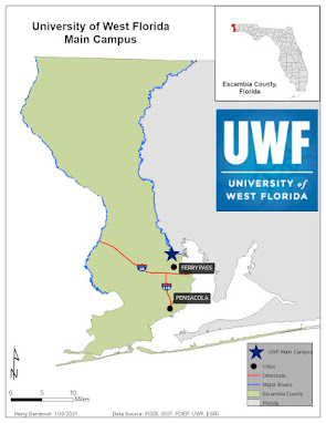
My lab for this week was to make a simple map which shows the UWF main campus location along with some significant surrounding features including cities, interstates, major rivers and the boundaries of Escambia County. It took longer than I anticipated to create the map as this was only the second time I have used ArcPro to create a layout. I think things will go a little faster in the future now that I know where to find things. As for the map that I created I think it looks a little drab. I would have liked to show a little more such as lakes, the ocean and perhaps adjacent states. I am sure that in future assignments the maps will start to get more complex and more interesting.
Saturday, January 30, 2021
Saturday, January 23, 2021
GIS 5050 Week 1 Lab Assignment.
This weeks lab assignment was to complete a crude map of the world. Very little data went into the creation of the map included above. I have been using ArcMap for well over a decade now and only I only use ArcPro for stitching together imagery that I acquire from Unmanned Aerial Systems. This lab allowed me to make a map layout in ArcPro which I had never done before. I always thought it would take a long time to figure out how to make a map layout in ArcPro but it was not bad at all. I can't wait to really get into making more sophisticated layouts in ArcPro.
Subscribe to:
Comments (Atom)
GIS 6005 Communicating GIS Final I have reached the final assignment of this course. This week we had to put all the skills that we learned ...

-
This week I worked on the assignment for Module 5. Module 5 had to do with choropleth maps. This assignment was fun but a little challengin...
-
Photo Interpretation and Remote Sensing This week in class we learned about the different factors that could interfere with Electromagnetic...
-
GIS 5050 Week 1 Lab Assignment. This weeks lab assignment was to complete a crude map of the world. Very little data went into the creati...


